Bare Earth №1
Every vineyard begins as a bare-earth DEM: roofs stripped, trees stripped, only ground remaining. That is how we first saw this hill — a bare-earth model from the LiDAR, half-metre truth. An honest name for an honest start.
33432 North 7th Street · Phoenix, Arizona · Sonoran Desert
Hillshadow is a small vineyard taking root on a desert foothill in Tramonto — the Italian word for sunset — north of Phoenix. Every contour on this page is the real ground, measured to the half-metre by a 2020 USGS LiDAR overflight, and you can walk it in your browser. The first bottles are a few seasons out. The sunset pours every evening.
Walk the terrain → Meet the first releases ↓
Three names, waiting for wine. There is no vintage yet — we will not pretend otherwise. But when this hill decides it is ready, these are what it pours.
Every vineyard begins as a bare-earth DEM: roofs stripped, trees stripped, only ground remaining. That is how we first saw this hill — a bare-earth model from the LiDAR, half-metre truth. An honest name for an honest start.
Drag the sun in the terrain viewer and the hillshade redraws. At 315° northwest, the hill wears the same light the late-afternoon desert gives it — the light the grapes will ripen under. A wine named for an angle.
Ground elevation of the house, NAVD88, in metres. One number on the label that says everything about where the wine grew — a coordinate you can verify yourself in the viewer, on this page, today.
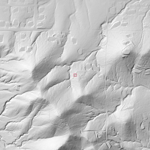
One lot in the Sonoran Desert foothills, near Carefree Highway and Cave Creek. Graded ground, drainage lines, boulders, berms — all of it recorded at half-metre resolution by the 2020 overflight. We don’t describe the site in adjectives. We show it in contours.
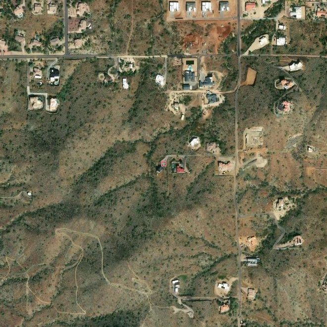
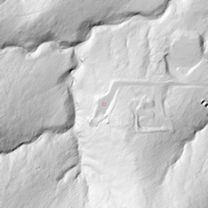
Prefer to walk it? The same LiDAR, rendered live — walk the hill in 3D →
Drag the sun. At 315° northwest, the hillshade draws the same shadows the late-afternoon desert does. The name Hillshadow comes from this: the shadow of the hill, computed from the actual geometry of the ground. Light here isn’t a mood. It’s a measurement.
On this page the dial only turns the needle — in the live viewer this same slider re-renders the hillshade from the actual geometry of the ground. That’s the same light that hits the vines.
One day on this hill, sunrise to sunset — from the Hohokam to the highway song to the vines going in. Read the short lines with your glass; open any entry for the note and its sources. Where the record hedges, so do we.
Hohokam canal-builders arrive from the Salt River Valley.
Hohokam farmers arrived in the Cave Creek area from the Salt River Valley around A.D. 700. The riparian corridor of Cave Creek itself is fed by a spring-fed stream the Desert Foothills Land Trust calls two million years old.
Sources: Jewel of the Creek Preserve History — Desert Foothills Land Trust
A mining and ranching outpost, and a stop for the U.S. Cavalry.
The town of Cave Creek, a few miles north-northeast of the vineyard, was established in 1870 as a mining and ranching outpost and a stop for the U.S. Cavalry. It kept its Old West character and incorporated as a town in 1986 — its fortieth anniversary falls in 2026.
Sources: Welcome to Cave Creek — official site · Carefree & Cave Creek Towns History — Chamber of Commerce
Cave Creek grew before statehood; Carefree after it.
The two towns of the Desert Foothills — Cave Creek (pre-statehood) and Carefree (post-statehood) — share Black Mountain but deliberately different origins.
Sources: Carefree & Cave Creek Towns History — Chamber of Commerce
Henry Schuerman was growing grapes near Sedona before statehood.
Arizona's winemaking past is older than its AVAs: in the late 1880s, German immigrant Henry Schuerman ran a substantial vineyard and winery on Oak Creek near present-day Sedona, supplying the mining camp of Jerome — an earlier era when wine, mining, and the desert foothills already ran together.
Sources: History — Arizona Wine Growers Association
See the first releases.
K.T. Palmer and Tom Darlington draw a town from scratch.
Carefree, just up the highway, is the opposite origin story from Cave Creek: a master-planned community conceived in the mid-1950s by business partners K.T. Palmer and Tom Darlington. Land sales began in 1955, homebuilding in 1958, and the town incorporated in 1984 to avoid annexation by Scottsdale. Its street names — Easy Street, Tranquil Trail, Ho and Hum Road — are the town's signature whimsy.
Sources: Carefree, Arizona — Wikipedia · Carefree General Plan (town history chapter)
Thirty miles from US 60 to I-17, past Lake Pleasant.
State Route 74 was commissioned in 1964; it runs about 30 miles from US 60 near Morristown (south of Wickenburg) to I-17 in north Phoenix, passing Lake Pleasant. The “Carefree Highway” name formally applies to the stretch from I-17 to Lake Pleasant Parkway.
Sources: Looking back at SR 74 opening in 1974 — ADOT · Arizona State Route 74 — Wikipedia
The same year, Gordon Lightfoot takes the name from a road sign.
In 1974, the same year the road opened, Gordon Lightfoot released “Carefree Highway.” He took the name from a road sign he saw driving from Flagstaff to Phoenix and — per his own account — carried it in a suitcase for eight months before the song followed. The single reached the Billboard top 10.
Sources: Turning back the pages on Carefree Highway's top 10 hit — ADOT · Carefree Highway — Wikipedia
Arizona's first federally recognized viticultural area.
The Sonoita AVA in Santa Cruz County was established by ATF rule in 1984 — the state's first federally recognized viticultural area.
Sources: Establishment of Sonoita Viticultural Area — TTB final rule · Sonoita AVA — Wikipedia
See the first releases.
The Old West town makes it official.
Cave Creek incorporated as a town in 1986, keeping its Old West appearance and character while the valley grew toward it. The town marks its fortieth anniversary in 2026.
Two hundred square miles of wine country, an hour and a half north.
The Verde Valley AVA in Yavapai County — about 200 square miles, overlapping Oak Creek — was established in November 2021. Arizona's modern wine industry is young but federally recognized.
Sources: Establishment of the Verde Valley Viticultural Area — Federal Register
Granite, washes, and saguaro slope — the ground the vines will grow in.
The lot sits at roughly 592 m (1,943 ft) NAVD88 — low Sonoran Desert foothills, the elevation band where the Phoenix valley floor gives way to granite outcroppings, washes, and saguaro slopes. The Cave Creek area's elevation range is 1,804–3,924 ft. The 2020 USGS LiDAR overflight that powers this site's terrain viewer recorded that ground at 0.5 m resolution; it is public-domain data anyone can check.
Sources: Welcome to Cave Creek — official site · USGS OPR AZ_MaricopaPinal_2020_B20 — staged products
See The Land or walk the terrain.
9,600 acres of protected desert, a short drive away.
Today north Phoenix protects 9,600+ acres of it as the Sonoran Preserve, with trailheads a short drive from the vineyard.
Sources: Sonoran Preserve — City of Phoenix
Elevation is one of the two things that decide where Arizona grapes grow.
Desert viticulture is a studied discipline, not a novelty: University of Arizona Cooperative Extension runs statewide commercial viticulture programs, and elevation — which moderates the low-desert heat — is one of the two main climatic determinants of where grapes can be grown in the state. National press now covers Arizona as “America's newest wine country,” with the open question of growing wine in a drought-state debated on the record.
Sources: Grapes for Central Arizona — UA Cooperative Extension · “An Arizona malbec?” — The Guardian, 2023
The Italian word for sunset — and the name of this hill.
The vineyard sits in Tramonto, a master-planned community in north Phoenix, east of I-17 along Carefree Highway, built among the desert foothill hills north of the highway. “Tramonto” is Italian for sunset — the word itself is solid; the developers presumably named the community for that desert-sunset image; no official naming record was found. An unnamed-for-maps granite high point that locals call “Tramonto Peak” rises about two miles northeast of the I-17 / Carefree Highway interchange — the same foothill terrain the vineyard's LiDAR records. Sunset here is the daily event the brand is named for. The next entry on this timeline is the vineyard's.
Sources: Tramonto Community Master Association · Tramonto — North Phoenix News · tramonto, etymology — Etymology Explorer · Tramonto Peak — surgent.net
See the first releases.
The sun has set on the story's day. The bottles are still a few seasons out — until then, the best thing we can pour you is the land itself.